
Tuesday, 30 October 2012


29th OCT.
Woke a few times in the night with strong winds and rain slapping the tent. I eventually woke at 6.45 gmt and due to lack of meths had cereal. It was a nice respite from waiting for water to boil.
We got packed up with the odd view below revealing chequered fields , clouds scudded from west to east.
We were to walking at 7.45gmt. It was fairly good walking and we were well wrapped with snugpaks , gloves , and hill hats. The path was easier than farm land, slabs laid to prevent erosion .
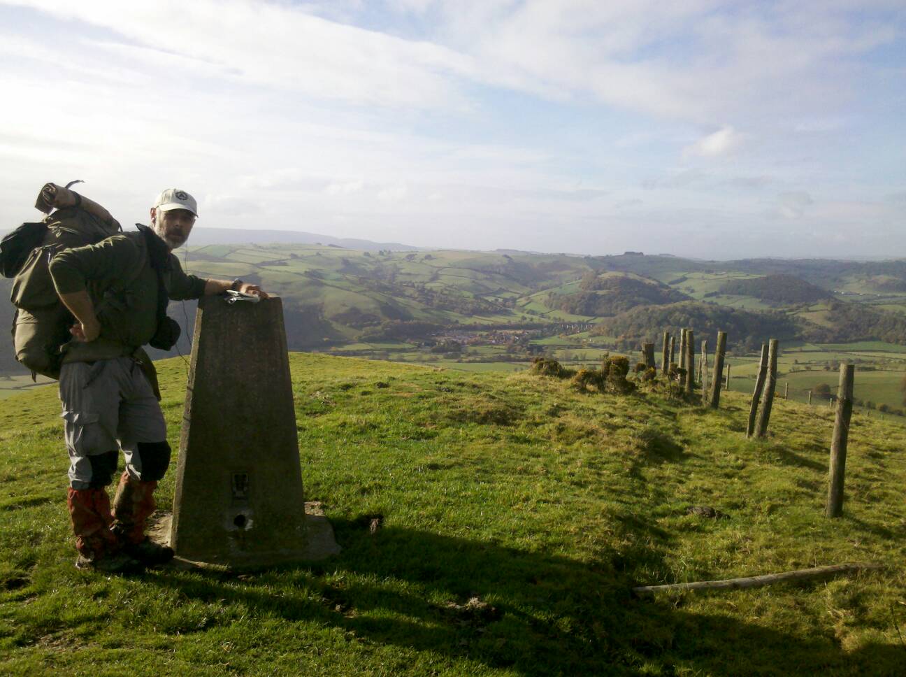
We made good headway on fairly flat top. The only indicator of where we were was trig points on the ridge.
Views were alot better, but then again the views yesterday were non existant so even with one eye closed it would be better.
We were walking along the Welsh/English border so in theory could of had one foot in each. To the left Wales looked formidable, steep sided hills clad in cloud tumbled away into the distance, where to the right England, gentler more inviting green with subtle hills.
We passed the three trigs in gradual descending heights. The odd grouse was put up , grouse shooting butts reminding me why they were there-sport!
We skirted Hatterrall Hill descending from heath to dreaded farm field, but luckily mostly via track and lane.We reached Pandy on the A465 and sat beside it eating bread and hard nuttella wondering where a shop may be.
Whilst sat there fine threads of spider web drifted around us, at first I thought I had a hair across my face. Looking at J's hair he had five money spiders on the tips of his stand up blond dyed hair.
We struck out along the road to
the village of Llanvihangel with its ' oldest pub in Wales', it must of had a few facelifts as it looked old but not that old.
Once we had had a drink we walked on in drizzle from lane to mud fields which were badly signposted before the village of Llangattock.We wondered up and down a fence line trying to find the correct exit, not easy when the fence line is muddy up and slip sliding down. We then ignored the signpost and found our stile on the higher fence line.
When we got into the village we passed via a white 12/13 century church with faded paintings of St George slaying a dragon. I will have to google it as there appeared to be an interesting history.
Walking on over field and lane via the White Castle, another 12 century land mark before descending into Llantilio Crossenny in the rain. We started looking for a stop off but empty farms and Bulmars cider orchards, with the smell of apples in the damp air, of course as the owners or directors were not available we had to walk on. The path took us through the orchard with heavy machinary spoiling the vision of hand cropped cider. The apples were incredibly small and hundreds of windfalls.
We walked on in dimming light to The Grange where luckily we were put next to a horse paddock. The young mother had gone out of her way to help with toddler tucked under arm.
We had stilton and brocolli soup which was warming and the last of our meths, J over salted his so he had to do without.
I nestled down listening to the radio feeling damp and dirty. We could do with a shower.
I woke having left the radio on- Hurricane devastating the USA , I felt lucky.
Sunday, 28 October 2012
28th OCT.CHURCH HOUSE NEAR HAY ON WYE TO Overlooking BLACK RIDGE, BRECON BEACONS
I Woke to a slight drizzle on the tent and all I could think of was - Great! We are going up and onto the Black Mountains today , if only the cold snap had lasted one more day.
It was pretty dark in contrast to the full moon shining on the tent last night.
I got the radio on reminded that instead of 6.45 Bst it was now gmt and 5.45. It made no differance as we still had to get going.The the weather outside and did not encourage movement though.
We had enough water for porridge and a tea for J , I would go without as the Earl Grey tea from Morrisons was awful.
We got the routine done, pleased with the fix to the pole especially as we would wild pitch tonight.
We got moving in a slight drizzle. Our host came out just before we left to offer us a shower, good of him but we thanked and said we had to get going ,even if we did smell!
J'S hair had sorted itself out from near dreadlocks.
We walked down the road then through an idylic woodland with numerous varieties of fungi. Sadly the the route then went through muddy fields and dropped to the River Wye.
We were soon in Hay- on -Wye where we wondered around on this quiet Sunday morning , into a cafe for coffee - the Granery, tasted like instant, passed numerous bookshops, an outdoor shop to get a new map case and clothing waterproofer and stood in the street spraying each other ,the castle and popped into Herefordshire to the co op for basics that did not need cooking ,we were nearly out if meths.
We just could not get out of Hay, even in drizzle it had a good feel. We went into the Blue Boar for a warm up coffee , alot better. It was a shame there was no wifi as I would of liked to of got my blog updated.
We finally started to walk out getting alittle confused which direction to go around the tourist nformation office,which was convienently closed. Eventually having wondered around looking lost we found our route.
We were to climb gradually, via farmland, then more steeply on very chewed up paths which increased the effort. This time horses were the cause but in places their hoof indents in the mud created steps.
We came out on flater moorland with a view up to Hay Bluff at 677metres over 2000 ft. A slight drizzle and increased had us donning our waterproofs. We made our way gradually up but feeling light headed I stopped for some bics. I had not eaten since breaky and had only had coffee and an energy drink.
We knew our mileage would be lowraising due to our sightseeing of Hay, but we needed to get on.
A trio came down from the misty tops, our route, and we asked how the going was. They said wet, they were not that well dressed for the weather.
We climbed the steady incline just below Hay Bluff at to gain the top. It was fairly flat with slabs of stone to prevent soil erosion and bags of stone to repair further paths. In better weather the walk would of been easy an pleasant, with good views, however we had strong westerlies with driven drizzle. We put our heads down and listened to radio 4 play - Frankinstein. It passed an hour after which we found a place to pitch on the eastern side of the path. We were still fairly exposed but on writing this. are warm. We ate baguette olives salmon and coldslaw.
The wind and rain has increased but I feel confident the tent is pitched well. It is dark now.


27th OCT. YEW FARM TO NEWCHAPEL approx. 4 miles north of Hay-on-Wye
I woke up in the dark and straight away noticed the cold. Opening up the inner tent I could see the twinkling of frost on the outer tent. I opened the flap to see a clear sky with stars shining bright, Orion constellation standing tall. A bright star to its left I did not recognise so using the excellent google stars app I was able to ascertain it was Jupiter.
I was not cold but put my hat on anyway while I lay in mt sleeping bag cooking the porridge.
Jay woke to stating he was chilled so I suggested he sleep in his clothes like I do.
We packed up a frosted tent and at 8.30 walked on icy ground with low raising sun clad in winter gear, gloves soon and thermal hats.
It was the a lovely day, with chilly breeze on our backs as we trudged south.
The route was refreshing undulating gently. No major climbs, just easy steady hills. When we stopped two hours later between Herrock and Rushock Hills only briefly due to chill.
We ,or should I say I ,mucked
up the route down to Kington and ended up skirting. BRADNOR Hill golf course, the highest in uk at 391 metres ,then I missed the path and took the less direct road.
We walked passed the Kington youth hostel and onto the main street.Ot had a nice feel, old and interesting. Again chips filled our bellies as we found a bench in the sun.
We did not hang around ,walking out via the steady Ridgebourne Road up to an old racecourse.
Views of the Black Mountains ahead. The top along Hergest Ridge was again easy going along dieing bracken and horse grazed heath. J wore a head scarf I bought him from Knighton. He wanted something to keep his hair out of his eyes. He looked like an aging rocker but it did its job.
We descended to Gladestry and had hoped to get a drink from the pub but at 3.10 it had just closed. There were a lack of streams on the gentle hills so thirst was an issue. It woyld of been harder mid summer.
Two and a half miles on we were able to use a stand pipe which was marked on the map, it tasted of creosote so we did not drink much.
More heathland was passed to Newchurch regreting not asking a friendly woman at a farm for a pitch. It was five, abit early to stop but started soon after trying to ask for a pitch.
Farm after farm appeared empty, again we walked on. It was getting dark, luckily the moon shone bright.we asked at a house with camper van. Luckily they were friendly interested folk and put us in their orchard,it was gone 6.30.
We soon had tent up, coffee on. Relief to stop. My feet were sore, J's hip ached and I had taken some weight off him.
I did three days blogging, J finished off the chilli sauce and rice - what a mess!
We listened to a play- Dracula during which the house dog discovered us and yapped endlessly until dragged in. Will be a cold night!


26th OCT. YEW FARM ,DOLLEY
26th OCT. The day was overcast on starting, dry with the sun that almost warmed us. This time retracing the way back to Knighton gave us views and on arrival we popped onto the Offas Dyke Centre to gain more info than the guide book. We were pretty thirsty and had worked up a heat even though there was a fairly cold northerly wind.
Once educated about the Dyke we went to the market place and ate chips and in the sun then again into the Costcutter bakery for a refreshing cuppa.
J had failed before with the shopping and I wad determined to do a better job. I trawled the Spar and Costcuttonh stores and bought expensive crappy dehydrated soup and a jar of decent sauce for pasta.
On the way back out I noticed a petrol station with a store, it was like a tardis, like a maze going deep into a large supermarket. It was cheap and would of saved alot of hassle looking for ideal food for us. I grabbed a few bits then we walked on.
The route was refreshing, I actually felt we were going forward and south.
We always have concerns over dogs, especially farm dogs. Today we were accosted by a three legged dog and another one who was all bark until I growled back and it sculked off with tail between leg.
The day ended at Yew Farm after Upper Dolley.The pregnant bulging bellied woman was accomadating allowing us to pitch on a dry flat field.
Pasta and sauce for supper. Then good ol' Radio 4. We were snug in the tent eating two ginger cakes and a strong coffee.


25th OCT. SEVERN CARAVAN PARK(bunkhouse), Cilcewydd to between Mardu/Hergan
Weeks left after a cooked breakfast. It was a decent stop off that was well timed and boosted us.
We now had to get back to Knighton but as we have done that section of the path we are entitled to take any route.
We had started about 10 and began by walking the fairly busy B4388 road. This took is via Forden, which appeared on the map as two places two miles apart ,strange!?
We continued at reasonable pace following the Dyke before losing it as we headed into Montgomery. We could just see the castle on a rocky escarpment above the market town and I strained yo get photos over overgrown hedges. We made our way into the quaint centre dominated by the town hall at the end of the market place. It was lined with twee tea shops and other multi paned victorian Dickens style shop fronts. The weather was cooler than the past few days and still overcast but ee sat in on a bench while I ate chips and sent an important email to AGE Uk. I had to get my wording right so it took abit of time.
We left after an hour,walking road again to meet up with the Offas Dyke near Mellington Hall. This was the hard bit, the three or four steep ups and downs. Revisiting Churchtown, the place without the town, this time we went in search of the meanstone, a stone used to weigh corn. We found it infront of the pulpit.
We left in the light diming, climbing up passed the CARE premises then down again more than ready to stop. The first place we came to ,now in fine drizzle , was a cottage minus the farm. The chap pointed out a spot which was hard to get pegs into but determination got us pitched. So pleased to stop.
Wednesday, 24 October 2012
WALES - Route taken.

We have walked 1340 miles so far ,of which we have walked 700 miles in Wales ,with 100 miles
of the Offas Dyke( Welshpool to Chepstow) to be walked. We are aiming to cross the Severn Bridge and into England around the 1st November heading to the South West Coast Path National Trail ( 630 miles and longest official National Trail ).


24th OCT. ROWNAL FARM nr Montgomery to CILCEWYDD via Buttington and Welshpool
This is the second time I have typed this!
I did not sleep well. Although I was stripped to smelly undies it was stifling in the tent. I eventually woke at 6 in the dark and listened to the radio. I got the water on for the porridge and tea but did not light the meths properly and as a result wasted 20 minutes for nothing to boil.
The morning was wet again, a fine mist drizzle made sure everything was either wet or wetter. I put on clean dry socks but within five minutes of walking in long grass they were soaked.
We began the walk herding about 80 sheep along a narrow fenced stretch of path. They paniced and crushed at a gateway about 100 metres further on, and as we approached the scattered passed us, crashing into wire fence and trampling each other. We were pleased to climb the stile and leave them to recover.
The route was fairly flat as we were now on the actual River Camlad flood plain and into Forden for snacks from the garage. I phoned the bunkhouse/ caravan park on the last of our mobile battery to book for the evening. It was such a relief that we knew we had a dry place to dry out our gear and get ourselves sorted and revived.
The damp weather was taking its toll on us, our feet were getting soft and sore, what had felt like a month was only four days under the tent.
The knowledge of a decent stop spurred us on and lifted us. We zig zagged up via conifer woodland, numerous mushrooms benefited from the warm damp weather, to Beacon Ring then down to Buttington our target. We had been here over four weeks ago and now we could concentrate on heading south back to Knighton to complete the Offas Dyke and hopefully a smoother flowing route into England..We walked into Welshpool via the familiar canal heading straight for Morrisons for a late lunch. I left J there while I went and sought 8 mm copper central heating pipe to act as a sheath for tent pole repairs. If this does not work I will have to send for our reserve tent.
I got back and shopped for food goodies for the bunkhouse. Our packs were the heaviest yet as we walked via the Leighton Road to Cilcewydd and our bunkhouse. We had a brief set to with a stroppy farmer who had a go at us for leaving a footpath even though he had ploughed it up!
Mr. Oliver at the Severn Caravan/bunkhouse park met us on arrival and was more than helpful. The bunkhouse was fantastic, cosy warm and homely. It had all we needed and was great value for money at £12 each, the best value a
yet!
I spent the evening repairing tent pole , and sewing the tent and my pack. Josh sewed a pair of trousers threatening to expose him. The blog, this blogg ,was a pain as I lost a more detailed entry but at gone 1am was to tired to be as detailed as before.


Subscribe to:
Posts (Atom)